
What's On > News
Grey Lynn Park – Understanding the 2023 Flood and the Aftermath
The Night Grey Lynn Park Became a Lake
Auckland Anniversary weekend January 2023, Grey Lynn Park experienced the worst flooding in living memory. The consequence of an unprecedented deluge.According to NIWA, the rainfall was so extreme in some areas it equated to an entire summer’s worth falling in a single day, classifying it as a 1-in-200-year event. Our suburb, Grey Lynn received a substantial amount of this intense rainfall.
Contributing to the park’s flooding were six large stormwater pipes that directly channel water into the park. The amount of water pouring in overwhelmed the park’s natural capacity for absorption transforming it into a temporary lake.
Grey Lynn Park has an underground structure known as a bund. During the flood night, this bund failed, leading to a sudden release of floodwaters into the natural valley into the lower parts of Dryden, Cockburn and Hakanoa Streets.
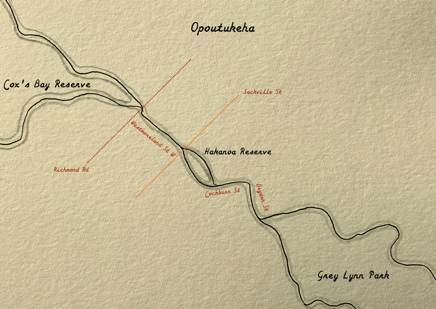
The Return of Opoutukeha
The land now occupied by Grey Lynn Park was originally a stream and wetland system called Opoutukeha. The intense rainfall of January 2023 saw this natural flow path return with a vengeance. The water flowed from the park down the Hakanoa Stream, down to the Farro and Mitre 10, across Richmond Rd by the Woolworths and joined the Cox’s Bay Reserve before flowing out to sea. Flooding whatever was in the rode.
What Happens Now?
The Auckland floods had a devastating impact across the city, leading to the removal of approximately 100 houses in affected areas following property buyouts managed by Auckland Council. This has resulted in significant tracts of vacant land, raising the question: what happens to this space now?
Decisions regarding the future of this land are being carefully considered, prioritising safety and flood resilience. Auckland Council intends to retain some land for future flood mitigation efforts, with the potential to transform these areas into new parkland or natural bush environments. Other vacant sites where safe rebuilding zones exist may be considered for sale and redevelopment.
In instances where land is deemed too hazardous for any form of activity, Auckland Council will ensure basic maintenance is carried out, including mowing and tree trimming. The Council may also utilize these areas for their own service-related needs as required.
Community Shaping the Future
It’s mentioned that Waitemata Local Board will play a vital role in the process on deciding the next steps, providing an opportunity for the community to voice their opinions and preferences regarding the future use of the vacant land.
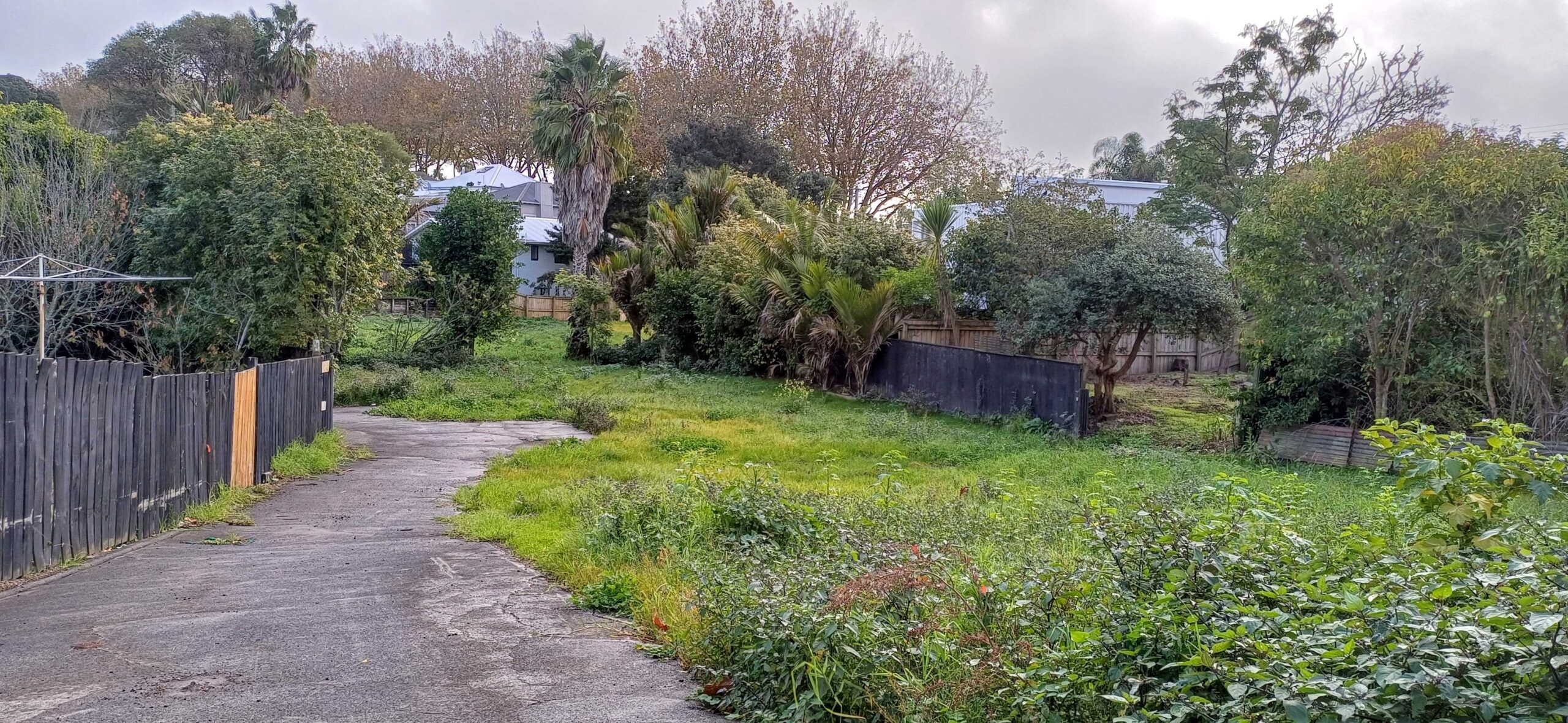

The vacant space at the bottom of Hakanoa, Cockburn and Dryden streets.
Learning from Others: A Community-Driven Approach to Open Space
Other cities facing similar challenges with vacant land have developed innovative approaches. The New York-based City Limits, for example, has developed a valuable Tool Kit designed to guide communities in collaboratively determining the future of open spaces.
This toolkit emerged from the community’s growing awareness of investment gaps in their open spaces and aims to amplify diverse voices throughout all stages of a project. It provides a clear, five-step framework for residents and their partners to bring their visions to life:
IMAGINE, PARTNER, DESIGN, BUILD, and ACTIVATE This model offers a potential pathway for the Grey Lynn community to actively participate in shaping the future of the land impacted by the floods.
https://www.communityfund.nyc/openspace
